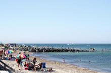
Two shorelines create a vast bowl around the waters of outer Edgartown harbor and Nantucket Sound, and, at first glance, the bluffs and beaches on either side look much the same.
Around this bowl (coastal scientists and engineers call it a cell) the water moves in somewhat contained and predictable ways. But that’s where the similarities between the two coastlines end, and the challenges and costs to hold both in place begin to diverge in radically different ways.
On the Martha’s Vineyard side of the cell, the coastline curves about six miles from the headland of East Chop to the fat, hooked thumb of Lighthouse Beach at the entrance to Edgartown harbor. On the Chappaquiddick side, the shoreline arcs smoothly over four miles from Cape Pogue to Chappy Point, also at the harbor entrance.
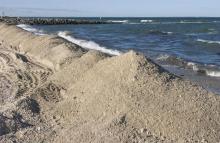
Scientists, engineers and waterfront workers say that sediment mostly circulates within the cell rather than wafting out to sea. And though people have long tried to control the... Read more...